
Just as the India Meteorological Department (IMD) indicated the beginning of the retreat of southwest monsoon from Rajasthan, heavy rains descended on the north-western plains. While this is certainly the last spell of seasonal rains before monsoon finally bids adieu to the country, the intense rainfall at the fag-end of the season has left many worried.
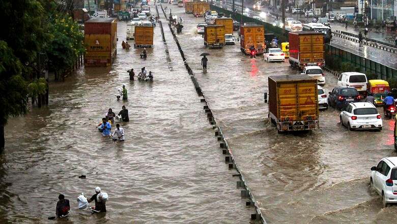
Over the last 24 hours, Palam in Delhi recorded 100mm rain — the second-highest 24-hour rainfall in September after 2011. Faridabad in Haryana recorded 155mm rains, while it was 115mm for Gurugram, 90mm for Haridwar, as high as 171mm for Etah in Uttar Pradesh, and 177 mm for Ballabhgarh (Haryana).
The widespread rains brought down the day temperatures to as low as 28 degrees Celsius, seven degrees below normal, in what many perceived as the slow start to upcoming winters. While the current spell may reduce the wide rain deficit in Uttar Pradesh, which was facing a shortfall of at least 43 per cent till September 15, it is set to leave the vast agricultural region in a tough spot.
The sudden downpour comes as bad news for paddy farmers of the Indo-Gangetic plains who are gearing up to harvest their crops. After bearing the brunt of deficient rains for most part of the season, the intense rains towards the fag-end can be extremely detrimental to the standing crops, especially in UP, and make a dent in the overall farm output from the region.
What’s Behind The “Untimely” Downpour?
For most part of the four-month season, the monsoon depressions/low pressure systems forming in Bay of Bengal followed a similar route. They entered the Odisha coast, and then travelled to as far as Rajasthan and Gujarat via Jharkhand and Madhya Pradesh. All these low pressure systems moved westwards, skipping the Indo-Gangetic plans completely and leaving them with a prolonged dry period.
But, in stark contrast, the last monsoon depression that formed in Bay of Bengal initially moved as a low pressure area to northwest Madhya Pradesh till September 15, pulled to a stop on September 16 and then began to re-curve towards northeast Uttar Pradesh as a cyclonic circulation during September 17-18, which triggered a spell of rains over the region.
To add to the momentum, a fresh western disturbance also impacted the region and began moving eastwards across northwest India towards UP during September 16-18. The two systems teamed up to bring intense widespread rains over Uttarakhand, HP, East Rajasthan, Haryana, Delhi and parts of Uttar Pradesh.
In fact, from September 15-21, Northwest India on the whole received rainfall which was 107 per cent above normal. As per the latest forecast, this intense spell is likely to continue over parts of northwest plains during the next two days, and last over Himachal Pradesh and Uttarakhand over the next three days before it begins to decrease.
Excess Rains In September
While the late September rains may have surprised many, it was not unusual going by the trends over the last few years. In 2021 too, September brought very heavy rains over the country, which was almost 35 per cent above its long-period average (LPA). Central India witnessed heavy rains to the tune of 84 per cent above normal, while it was 39 per cent for northwest India.
September 2021 broke the record for the highest rains in the last 28 years starting 1994 after 2019, which recorded excess rains to the tune of 52 per cent above normal. This was partly due to monsoon depressions and other favourable meteorological conditions.
This year, too, IMD had predicted above normal rains for September — 109 per cent above LPA of 167.9mm rains for most parts of the country, except many parts of East and Northeast India.
Monsoon’s Late Goodbye
While this is the last spell of seasonal rains before the winter sets in, it has further pushed back the withdrawal of monsoon from several northern states. Normally, the monsoon is expected to withdraw from most parts of north-west India, including Delhi, by September 25; Chandigarh by September 22; Jammu by September 22; and Haryana’s Sonepat by September 23. However, this year, it may be delayed by over a week at least.
“One of the critical indicators of withdrawal is a dry spell that lasts at least five days. But with the ongoing spell of rains, there is still time before that happens. Conditions are likely to become favourable for its withdrawal from some parts of northwest India only later next week,” Dr Sathi Devi, senior IMD scientist, told News18.
The delayed retreat is consistent with the long-term trend observed by meteorologists, which also led IMD to revise the normal dates for its withdrawal from the country last year. The normal withdrawal date from Rajasthan was revised from the initial September 1 to September 17.
However, the monsoon began receding from parts of southwest Rajasthan and adjoining Kutch on September 20 — three days later than the normal date. In fact, in 2021, it began withdrawing from Rajasthan on October 6 — recording its second-longest withdrawal since 1975.
Current Forecast
As of Friday, the withdrawal line currently passes through Rajasthan’s Bikaner and Naliya in Kutch, Gujarat, and remained the same till the end of the week. The monsoon withdrawal may not begin from some more parts of the northwest and some parts of Central India until next week.
According to IMD forecast, heavy rains will continue over Uttarakhand, Himachal Pradesh and Uttar Pradesh till September 26, and Haryana, Chandigarh, and East Rajasthan till September 24, and begin to recede after that. The momentum will then shift south, and Central and Peninsular India would witness scattered to fairly widespread rainfall and some thunderstorm/lightning activity post September 29.
As of now, the overall country-wide rainfall is 7 per cent above normal, with 26 per cent above normal rains over south peninsular India, 20 per cent above normal over Central India. The rainfall over northwest India is 3 per cent in deficit, while it is as high as 17 per cent for east and northeast India.
Read all the Latest News India and Breaking News here


Comments
0 comment