

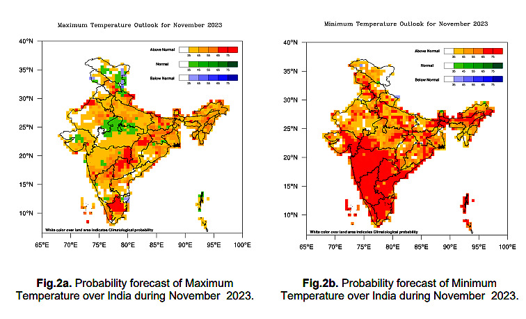
With the winter making its onset, some parts of Northwest India and west Central India could still expect temperatures to remain normal during the day, but they are likely to be higher during the night. This follows a warm October when the mean temperatures across the country were recorded to be 0.88°C higher than the long-term average. The All-India maximum temperatures in October had shot up by almost a degree — third-highest since 1901.
“We cannot rule out the overarching impact of climate change. The temperature rise is more pronounced during the winter months. Generally, El Niño years are warmer,” said IMD chief Dr M Mohapatra. “We expect the severity of winter to be slightly less at night for Northwest India, especially due to cloudiness on most days, as the region is likely to witness good rains this month.”
A natural climate phenomenon, El Niño is linked with periodic warming of the equatorial Pacific Ocean that has a powerful impact on the weather worldwide. In India, it is known to aggravate heat waves and weaken the summer monsoon, causing droughts. But it generally peaks in winter when northeast monsoon prevails over peninsular India.
60% RAINFALL DEFICIT OVER SOUTH INDIA
The IMD has forecasted normal rains for November, even though October ended up with a rainfall deficiency of nearly 32 per cent for the country, and a staggering 60 per cent deficit over South India due to a weaker onset of Northeast Monsoon. This is disconcerting as the winter monsoon provides 40 per cent of the annual rainfall to the region and its deficit can adversely impact the agricultural production in the region.
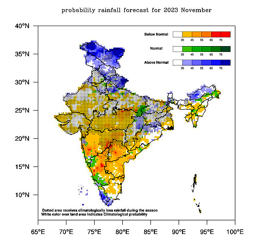
The northeast monsoon has remained subdued over peninsular India despite a favourable impact of El Niño. Except for a few heavy rainfall events in the extreme southern parts, most of the northern parts of the peninsular states have remained rain-deficient – which scientists have attributed to a combined influence of El Niño and a positive Indian Ocean Dipole (IOD).
SO WHAT’S NEXT?
The warm temperatures of the North Indian Ocean have already supercharged two cyclones in the Bay of Bengal and Arabian Sea in the past 10 days. IMD has ruled out any formation of cyclones over the next two weeks.
A characteristic feature of climate change, both the cyclones — Tej and Hamoon — intensified rapidly and moved faster than the normal average speed of cyclones, and veered away from the Indian coast causing no damage. According to meteorologists, the tropical cyclones generally move westwards during El Niño and positive Indian Ocean Dipole (IOD) years, so there is less likelihood of them impacting the northern parts of the peninsular India.
But they ended up dragging all the moisture and weakened the northeast monsoon. However, a fresh spell of rainfall is forecasted for Tamil Nadu, Kerala-Mahe and South Interior Karnataka from November 3-5. Overall, IMD has expressed confidence that the northeast monsoon would be normal and that range is wider — 72-123 per cent of the Long Period Average (LPA).
“South India has generally witnessed good rains during El Niño years in the past, however, this time they have been deficient so far. But if we look at the combined impact of El Niño and positive IOD, this rainfall is most concentrated in southern-most parts – which is exactly what we have witnessed,” added the Director-General of Meteorology, IMD.


Comments
0 comment