
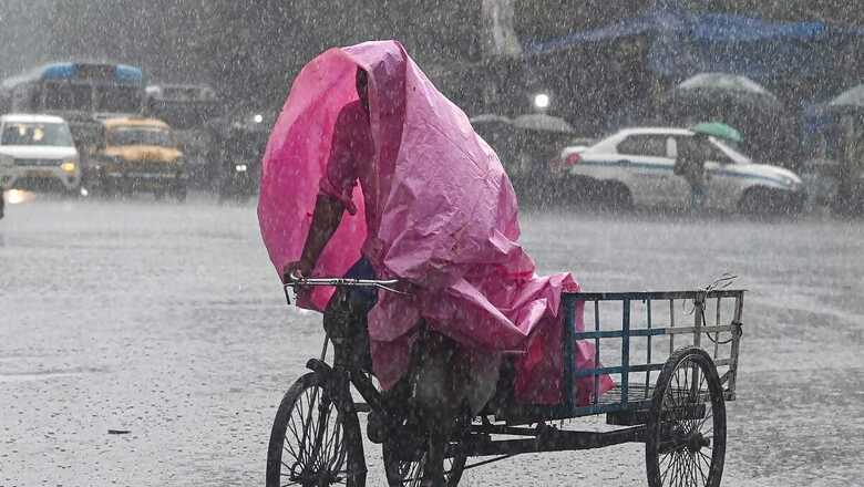
The southwest monsoon has covered the entire country six days ahead of the usual date, the India Meteorological Department (IMD) said on Tuesday.
“The southwest monsoon has further advanced into the remaining parts of Rajasthan, Haryana and Punjab today. Thus, it covered the entire country on 2nd July 2024, against the normal date of July 8 (six days before the normal date of covering the entire India),” the IMD said in a statement.
The monsoon arrived in Kerala and the northeastern region on May 30, two and six days earlier than usual. It progressed normally up to Maharashtra but lost momentum, extending the wait for rains in West Bengal, Odisha, Jharkhand, Bihar, Chhattisgarh, Madhya Pradesh, and Uttar Pradesh, and worsening the impact of a scorching heat wave in northwest India.
The country recorded 16 days of below-normal rainfall activity — from June 11 to June 27 — which led to an overall below-normal precipitation in June, 147.2 mm of rainfall against a normal of 165.3 mm for the month, the seventh lowest since 2001. June rainfall accounts for 15 per cent of the total precipitation of 87 cm recorded during the four-month monsoon season in the country.
The IMD on Monday said India could experience above-normal rainfall in July, with heavy rains potentially leading to floods in the western Himalayan states and river basins in the central parts of the country.
According to the IMD, heavy rainfall is very likely over Konkan, Goa, central Maharashtra, Kerala, Mahe, Coastal and South Interior Karnataka during July 2-6; Saurashtra, Kutch on July 2-3; Gujarat region during July 2-5, Tamil Nadu, Puducherry and Karaikal on July 2. Very heavy rainfall is very likely over Konkan, Goa, central Maharashtra on July 2 and 6; Saurashtra, Kutch on July 2; Gujarat region on July 3; Coastal Karnataka on July 5-6.
WEATHER FORECAST
A cyclonic circulation lies over southeast Pakistan and monsoon trough is north of its normal position at mean sea level. Under their influence, fairly widespread to widespread light to moderate rainfall accompanied with thunderstorm, lightning is very likely over Northwest and Central India during the next five days.
Heavy rainfall is likely over Jammu-Kashmir-Ladakh-Gilgit-Baltistan-Muzaffarabad on July 4-6, Himachal Pradesh, Punjab, Haryana-Chandigarh-Delhi, Uttar Pradesh, East Rajasthan during July 2-6; West Rajasthan on July 3; Madhya Pradesh during July 2-4 and Chhattisgarh on July 2-3. Very heavy rainfall is likely over Uttarakhand during July 2-6, Punjab on July 3, Haryana on July 2-3; West Uttar Pradesh on July 2-6; East Uttar Pradesh on July 5-6.
A cyclonic circulation lies over north Bangladesh, another over Assam and a trough runs from northeast Madhya Pradesh to the cyclonic circulation over Assam, in lower tropospheric levels. Under their influence, widespread light to moderate rainfall accompanied with thunderstorm, lightning with heavy to very heavy rainfall very likely over Northeast India, Sub-Himalayan West Bengal and Sikkim and scattered to fairly widespread rainfall over East India during the next five days.
Heavy rainfall is very likely over Bihar, Sub-Himalayan West Bengal & Sikkim, Nagaland, Manipur, Mizoram and Tripura during July 2-6; Andaman and Nicobar Islands on July 4-5; Gangetic West Bengal on July 3-4, Jharkhand during July 2-4; Odisha on July 6. Very heavy rainfall likely over Bihar on July 2-3; Arunachal Pradesh, Assam and Meghalaya during July 2-4; Sub-Himalayan West Bengal, Sikkim, Nagaland, Manipur, Mizoram and Tripura during July 2-5. Extremely heavy rainfall very likely over Arunachal Pradesh, Assam and Meghalaya on July 5 and 6.
A cyclonic circulation lies over north Gujarat, neighbourhood in middle tropospheric levels tilting southwards with height. The off-shore trough at mean sea level along Maharashtra-Kerala coasts. Under their influence, widespread light to moderate rainfall accompanied with thunderstorm and lightning is very likely over Kerala, Mahe, Lakshadweep, Coastal Karnataka, Konkan, Goa, Gujarat; scattered to fairly widespread light to moderate rainfall over Madhya Maharashtra, Coastal Andhra Pradesh, Yanam and Interior Karnataka; isolated to scattered light to moderate rainfall over Marathwada, Tamil Nadu, Puducherry, Karaikal, Rayalaseema, Telangana during the next five days.
With PTI Inputs


Comments
0 comment